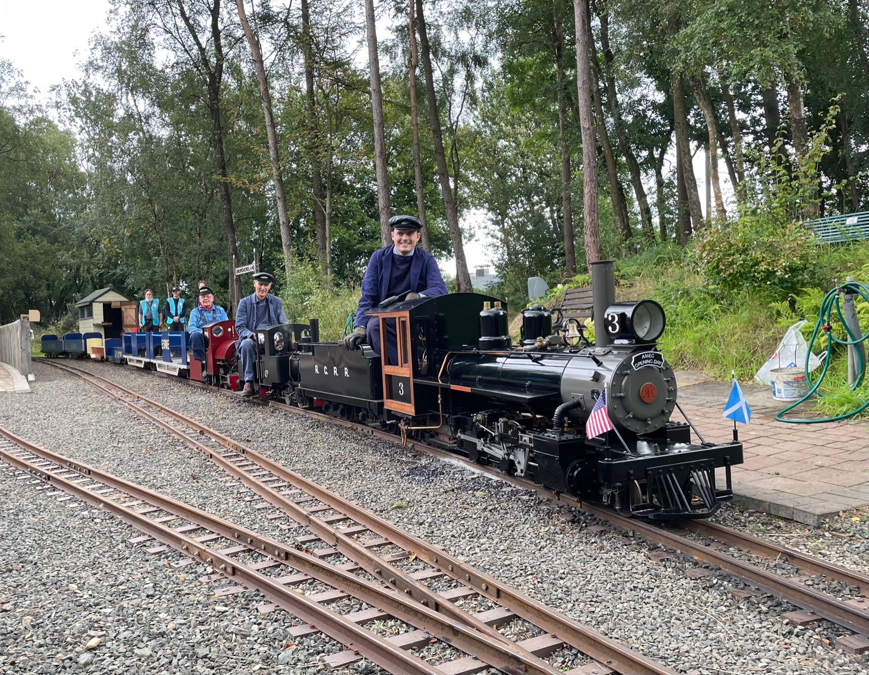
Excavations for the Comrie circuit were progressing nicely until, to James’ consternation, there was a dull thud as the Kubota bucket struck something very solid! No amount of effort would persuade it to move.

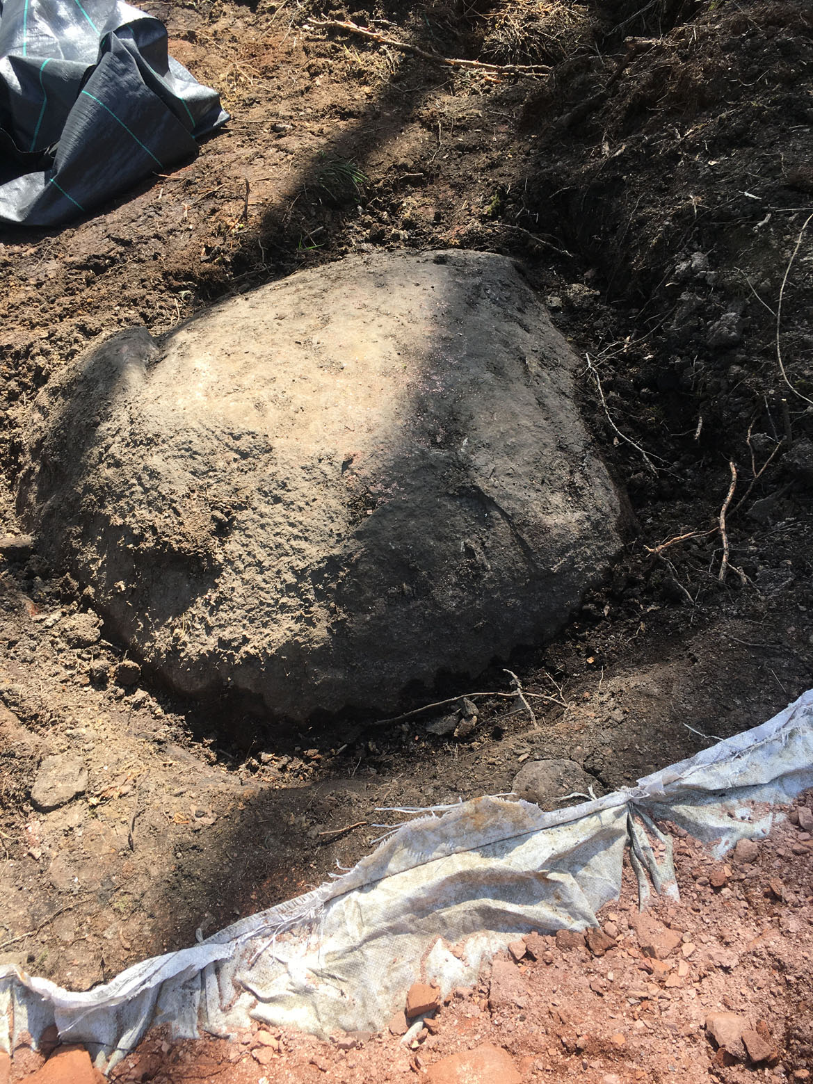 Resorting to shovels the true size of the stone soon revealed itself. A rock of this scale had never been found before on the site which gave us a mystery to solve. Why is it there & how did it get there? Various theories were proposed ranging from an ancient mine cap to a Meteorite.
All this speculation led to an approach to the British Geological Survey who very kindly came up with this report:
The ‘Drumshoreland Boulder’ – Author: Sarah L B Arkley of the British Geological Survey [Provided under licence CP21/030 BGS © UKRI]
There are two parts to this investigation – a) is the boulder, that was uncovered during groundworks at Drumshoreland and measures approximately 5ft in diameter, a glacial erratic? And b) could the boulder be covering a mine shaft? The first question can be answered by investigating the unconsolidated (artificial and superficial) deposits recorded at the site to establish the most likely reason for the boulder being there. The second question can be largely answered by investigating the solid rocks (bedrock geology) underlying the boulder’s location to see if any mineral seams of a workable thickness are present, checking available mine plans to see if any of the seams were mined in the vicinity of the boulder and if there is any record of a shaft to any workings at the site of the boulder. The location/site of the boulder is at grid reference NT 08480 70362, which was provided by the Edinburgh Society of Model Engineers (ESME) when they contacted the British Geological Survey (BGS).
Is the boulder of glacial origin – probably yes
How has the boulder come to be there? Is it there naturally or has it been moved to its current position? The most recent 1:10 000 scale BGS geological drift map (published in 1992) illustrates the extent of artificial deposits in this area, i.e. where the ground surface has been significantly modified by human activity. The map shows a large area of ‘disturbed ground’ and a small area of ‘made ground’ just west of the boulder’s location – these are likely associated with former shale workings from the Roman Camps mines, but there are no artificial deposits recorded at the site of the boulder. The absence of any ‘made ground’ or ‘landscaped ground’ at the site would suggest that the boulder is therefore in its natural position. Note: there is always the possibility that small or thin areas of made ground could exist unrecorded, a single ‘out of place’ boulder is unlikely to be recorded on a map of this scale. However, if a shaft had been dug at the site there would probably be some evidence of disturbance or ‘spoil’ in the immediate vicinity. Also, the boulder is a significant size at 5ft diameter and appears on the photographs provided by ESME to lie below a fairly level ground surface, if it had been placed there by man, they must have dug a hole to put it in, so it is likely the surrounding material would be disturbed from back filling it and/or excess material would be mounded up around it.
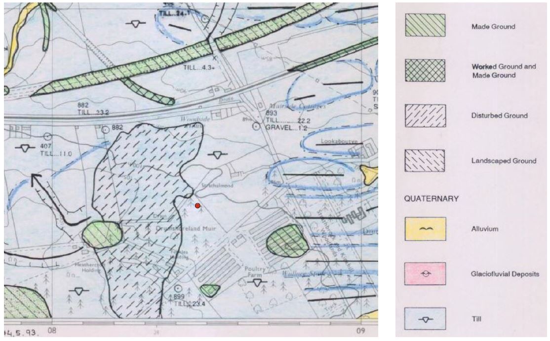
Extract of the 1:10 000 scale BGS geological drift map (sheet NT07SE) showing artificial and superficial deposits. The approximate location of the boulder is indicated by a red dot.
The BGS geological drift map also records the natural superficial deposits in the area. The deposits underlying the boulder site are thought to consist largely of glacial till (boulder clay). Glacial till, as its name suggests, was deposited beneath glaciers during the last ice age which melted away in this area around 16,000 years ago. It is typically a firm to very stiff, silty or sandy clay with rock clasts, of various types, and up to boulder size. Irregular beds or lenses of sand and gravel, or silt and clay may occur within or above the till. The top metre or so of the till is commonly weathered, siltier and might be soft to firm. Borehole records in the area indicate the thickness of the till could be around 20 m.
In West Lothian, any large boulders found in deposits of glacial till are typically composed of dolerite. Dolerite is a dark coloured rock, composed of interlocking crystals so is generally strong to very strong when fresh and in the absence of internal fractures would remain intact when transported by ice, although the overall shape would become increasingly rounded with increasing transport distance and surfaces may display striations (scratches). An unpublished BGS fieldslip from 1941 records “Many large dolerite boulders” in the Caw Burn, approximately 750m NW of the boulder site, suggesting that large dolerite boulders are common in the local area. Farmers often removed such boulders from their fields so they didn’t damage farm machinery and left them piled at the edge of fields.
Extract from a 6 inch scale BGS fieldslip (sheet Linlithgow 8SE) where the survey geologist has noted ‘many large dolerite boulders’ close to the site. The approximate location of the boulder considered in this investigation is indicated by a red dot.
Summary
The photographs provided by ESME of the large boulder at Drumshoreland appear to fit with that of a glacially-transported boulder (technically, it’s only an ‘erratic’ when sitting on a different lithology), found naturally within deposits of glacial till. It is probably composed of dolerite (although this could not be confirmed without inspection) and is likely to be pretty strong. Notes recorded by geologists in the past suggest that such boulders are common in the local area and suggest that ESME have maybe been lucky not to come across more of them during their excavations.
Could the boulder be covering a mine shaft – unlikely
Great question, this glacially-transported boulder could have been found locally and used to cap a shaft to make it safe. The first step here is to establish what the geology is beneath the site. The 1:50 000 scale BGS bedrock map of the area, sheet 32W, published in 2006 shows the solid rocks immediately underlying the site belong to the Hopetoun Member of the West Lothian Oil Shale Formation of Lower Carboniferous age (approximately 330-340 million years old). The Hopetoun Member is an 830 m thick sequence of sedimentary strata, characterised by interbedded sandstone, siltstone, marl (calcareous mudstone) and mudstone. Seams of oil-shale, along with thin seams of ironstone, coal and limestone are also present. A number of the oil-shale seams were of former workable thickness and economic importance in the area.
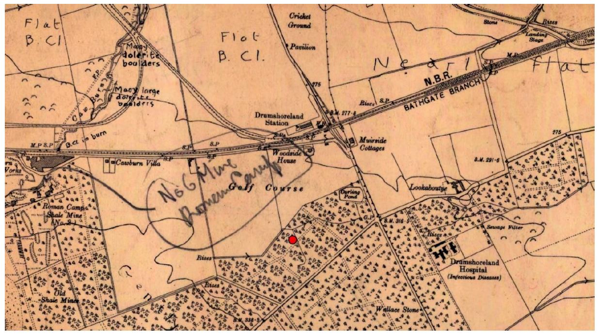
More precisely, as shown on the 6inch:1mile BGS geological map (published in 1962), the strata directly beneath the boulder’s location is thought to lie between the Under Dunnet Shale and the Camps Shale in the lower part of the Hopetoun Member. The Under Dunnet Shale is recorded to reach rockhead to the west of the boulder site, and as the strata is recorded to dip down towards the west in the vicinity of the boulder, the seam will dip away from the boulder and therefore not underlie it. The Camps Shale however is recorded to reach rockhead east of the site, this seam will also dip towards the west and therefore will underlie the boulder site. So, the geology directly beneath the site does include seams of oil-shale (albeit at some depth), therefore there is potential for mining beneath the site.

Extract of 6 inch BGS solid geology map (sheet NT07SE) showing bedrock units thought to be present at rockhead near the boulder site. The approximate location of the boulder is indicated by a red dot.
A number of the oil-shale seams in the West Lothian Oil-Shale Formation were of great economic importance and worked extensively across West Lothian, including the Dunnet Shale, Camps Shale and the Pumpherston Shales (of the underlying Calders Member).
A quick search of mine plan catalogues and data held by BGS revealed former oil-shale workings are present in the vicinity of the site, in the Under Dunnet Shale and in the Camps Shale, however no records were found of former underground mineworkings in any mineral directly beneath the boulder site (at the grid reference supplied by ESME). BGS seam maps of individual oil-shale seams in the area show a similar extent of underground workings to that shown on the Coal Authority Interactive Map. Both of these datasets indicate underground workings just to the west of the site but not directly beneath the site. The presence of unrecorded mineworking beneath the site in the Camps Shale cannot be ruled out, although borehole records held by the BGS, and summarised on the seam map, suggest that the Camps Shale was of poorer quality east of the recorded workings (i.e. beneath the site) and therefore is unlikely to have been worked.
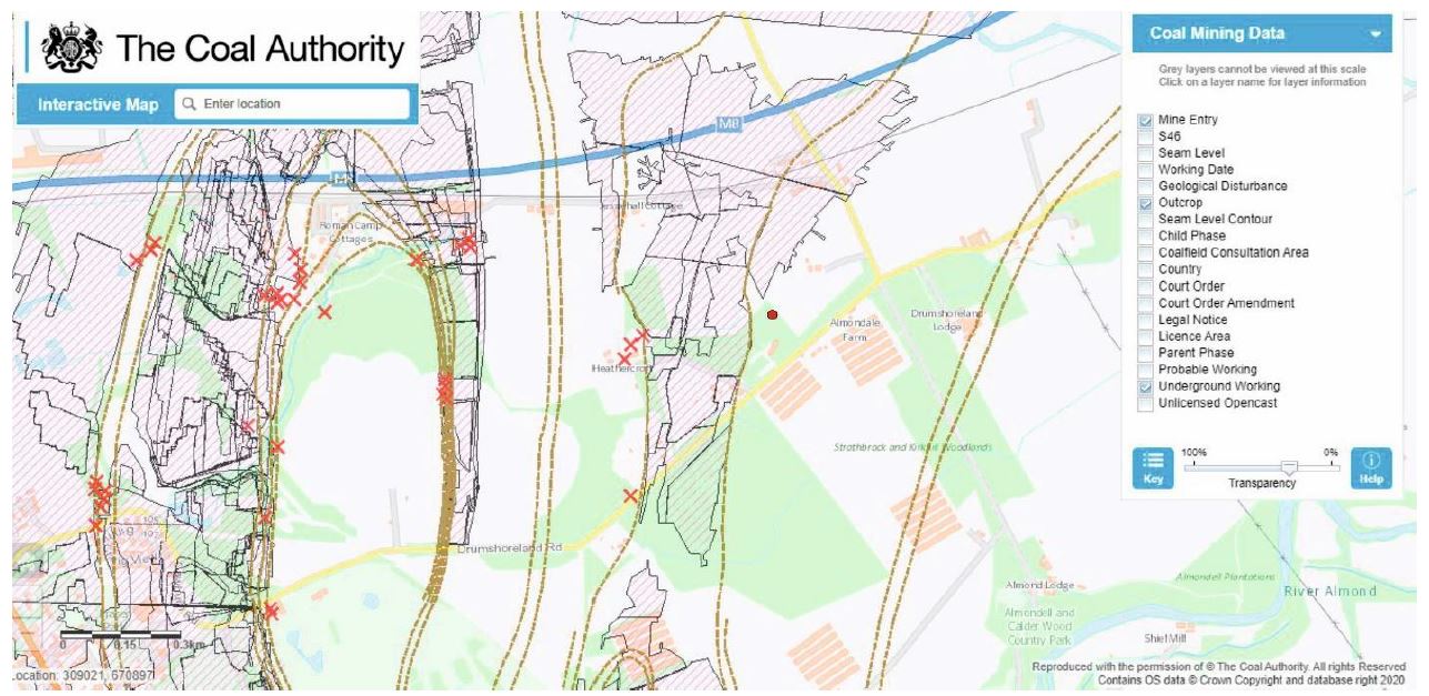 Screen shot of the Coal Authority Interactive Map indicating there are no known underground workings or mine entrances directly beneath the boulder site. The approximate location of the boulder is indicated by a red dot.
 Extract from the 6 inch BGS Camps Shale seam map (sheet NT07SE) indicating the seam is not recorded to have been worked directly beneath the site of the boulder (red dot shows approximate location) and that nearby borehole records indicate the seam to be of poorer quality east of the known workings.
Abandoned mine shafts and adits are known to be present in the area, associated with underground oil-shale workings from the Roman Camps mines, however no records of a shaft or adit at the boulder site were found on any of the plans viewed.
The Dunnet Sandstone lies between the Under Dunnet Shale and the Camps Shale beneath the site. It is a unit, recorded to be 200m thick in parts of Livingston, which contains thick layers of grey or brownish sandstone and is known to have been worked in parts of West Lothian as a building/dimension stone. Records indicate the stone was generally quarried from the surface rather than being mined underground, for example at Hopetoun the stone was quarried for the building of Hopetoun House from as early as the 17th Century. Although the sandstone may lie close to rockhead directly beneath the boulder site, with approximately 20m of glacial till overburden it is unlikely to have been economic to work it in this way here and there would almost certainly be evidence of its extraction if it had in the form of made ground or landscaped ground. No records have been found of the Dunnet Sandstone being mined in this area.
Summary
Geological maps show the solid rocks beneath the boulder site belong to Hopeton Member of the West Lothian Oil-Shale Formation which are known to contain thick seams of oil-shale. Available mine plans show the Under Dunnet Shale and Camps Shale were both worked locally, but do not record any workings immediately beneath the site. No record of a shaft at the site has been found.
More detailed information on the geology and mineworkings underlying the site could be provided through the provision of a BGS GeoReport and/or by contacting the Coal Authority.
Conclusion:
In conclusion, the large boulder found just beneath the surface at Drumshoreland is most likely to be a glacially-transported dolerite boulder, from the thick layer of glacial till which covers much of the local area. No evidence was found to suggest that the boulder has been moved from its natural placement. The solid rocks underlying the site at depth do contain seams of oil-shale which were worked locally, but the maps and mine plans viewed show no recorded workings in any mineral seam directly beneath the boulder site. Although there is the possibility of unrecorded workings, the existence of a shaft at the site is thought unlikely.
Additional information:
BGS has produced or contributed to a number of publications which can tell you more about the geology of the area and can be viewed online free of charge. Most BGS publications can be accessed through the publications viewer on the BGS website – BGS publications | OpenGeoscience | Our data | British Geological Survey (BGS), although I have included some direct links below:
A Landscape Fashioned by Geology:
• Edinburgh and West Lothian: A Landscape Fashioned by Geology. Scottish Natural Heritage and British Geological Survey. 2003 Landscape fashioned by geology – Edinburgh and West Lothian | NatureScot
Memoirs of the Geological Survey Scotland (Economic):
• The oil-shales of the Lothians: part 1: The geology of the oil-shale fields, part 2: Methods of working the oil-shales, part 3: The chemistry of the oil-shales (1st edition). Cadell, H.M.; Wilson, J.G.O.; Caldwell, W.; Stewart, D.R. 1906 BGS publications online
• The oil-shales of the Lothians: part 1: The geology of the oil-shale fields, part 2: Methods of working the oil-shales, part 3: The chemistry of the oil-shales (2nd edition). Carruthers, R.G.; Caldwell, W.; Stewart, D.R. 1912 BGS publications online
• The oil-shales of the Lothians: part 1: The geology of the oil-shale fields, part 2: Methods of working the oil-shales, part 3: Chemistry and technology of the oil-shales, part 4: History of the Scottish oil-shale industry (3rd edition). Carruthers, R.G.; Caldwell, W.; Bailey, E.M.; Conacher, H.R.J.1927 BGS publications online
Wartime Pamphlet Geological Survey of Great Britain:
• The oil-shales of the Lothians: structure, area 2: Pumpherston. Anderson, J.G.C.; Graham, W.E. 1942 BGS publications online
A selection of geological maps can also be accessed online free of charge through the maps portal on the BGS website – BGS maps portal – British Geological Survey:
1:50 000 scale geological maps:
• Sheet 32W (Livingston) 2006 British Geological Survey (BGS) | large image viewer | IIPMooViewer 2.0